Seeing a real life photo of the dwarf planet is not quite enough, you’d think, but New Horizons helps map the geological formation of Pluto too. It was only recently that NASA released a photo the space craft took of the area known as Sputnik Planum on the surface of the tiny member of the Kuiper Belt. But while that was what the public was shown, it wasn’t the only photo taken by New Horizons.
After the staggering discovery that the original picture taken by New Horizons with its Long Range Reconnaissance Imager (LORRI) in July 2015 was actually displaying floating glaciers, because of the density difference between the water ice as well as the frozen nitrogen that the planet’s plain mostly consists of, scientists took a closer look to what are the components that create Pluto’s geography.
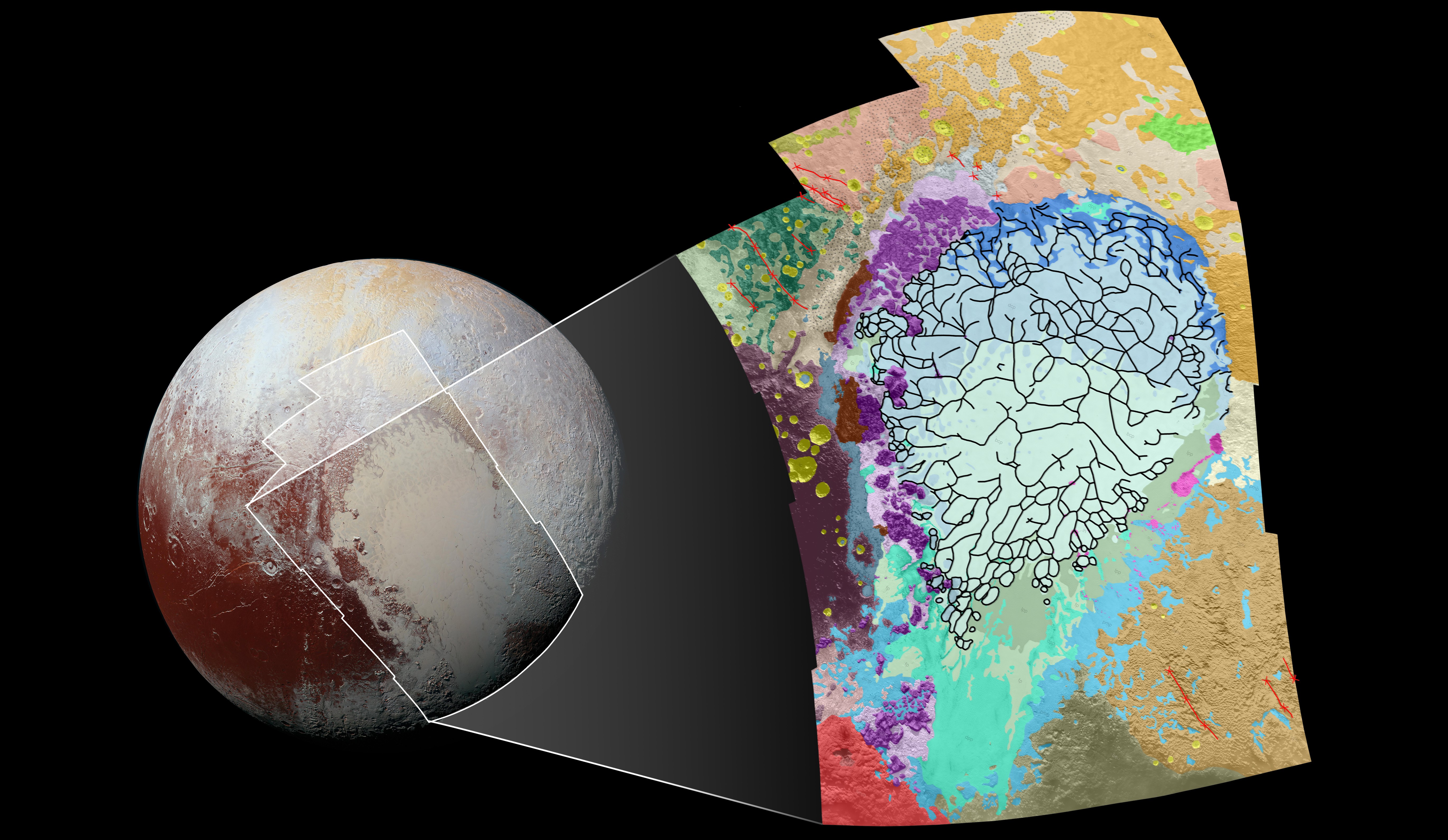
Researchers have actually managed to map as much as 1,290 miles across and around the Sputnik Planum in different visual wavelengths, depicting the different types of terrain on the surface of the frozen planet. The colored history of the map that was rendered in a scale of 1,050 feet per pixel should be able to reveal more of the geographical formation of the planet.
Therefore, purple areas indicate the blocky mountain edge of the Sputnik Planum, described by NASA as chaotic and angular and pink is the representation of floating ice. Yellow areas represent well-preserved impact craters while the darker brown areas are various types of uplands. To the west of Sputnik Planum, you can see rugged, heavily cratered material, while the very south western corner of the image shows hummocky mound material and a possible cryovolcanic feature named Wright Mons.
There are a lot of things scientists can gather from images such as this one because they provide a huge amount of insight into the history of the geographical formation of the planet’s surface. Considering that New Horizons has reached its destination and did its purposed flyby of Pluto last summer, now heading to unknown parts of the solar system, this was a secluded chance for humanity to see and try to understand the things that we may not see in person in the next few decades.
The geologic map was obtained by creating a mosaic of the 12 images that the LORRI device took of the planet during its flyby of Pluto from a range of 48,000 miles from the surface. Scientists say that this is a very important resource for the study of the planet as it’s an efficient method of understanding the processes that have undergone on Pluto to result in the planet’s battered and intriguing surface.
Image Source: 1